PERICLES is a coastal and maritime heritage project around Europe running from 2018 until this spring. Since the project nears its end, we thought it would be beneficial to see what they achieved.
What
PERICLES, at its core, is a participatory heritage management initiative, meaning that the processes of research, policy, implementation, etc., derive from work with local stakeholders and compiled to the broader European context.
Coastal cities from Ireland, Malta, France, Portugal, Estonia, Greece and Scotland participated.
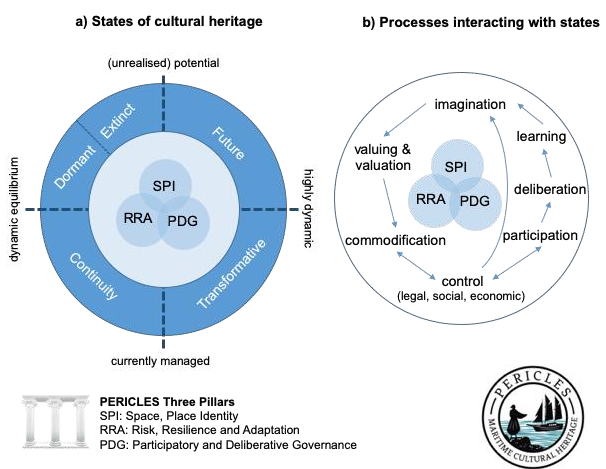
All projects stemmed from a specific methodology and tools adapted for each region. The conceptual approach is that heritage is not static but continually evolving, thus shaping the landscape, values and identity of its residents, and as such its needs and uses adapt.

©PERICLES
How
The project formed three pillars, each developing specific tools and methodologies:
Space, Place, and Identity: focuses on how space becomes place, meaning a physical site attaining values and identity. ( Space vs Place refresh your memory DIY Values Analysis, Public Space Architecture: capture communal identity)
Risk, Resilience, and Adaption: coastal heritage face immediate threats such as climate change, globalisation and over-tourism, however case by case, the threats differ in severity and ways to combat them.
Deliberative and Participatory Governance: informed through the other two pillars’ work, PERICLES provides a framework for communication and participatory sustainable management for maritime cultural landscapes.
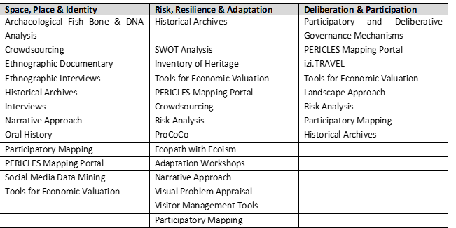
The tools and methodologies surrounding these pillars can be summarised within the table below, and further developed in templates accessible with the Internal Report on Initial Method and Tool Review.

©PERICLES
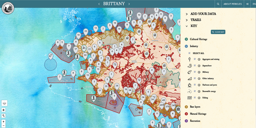
Cultural Heritage Mapping Portal
An online map open to all to contribute through this platform. (CHECK IT OUT ITS AWESOME)
As part of the tools produced to identify Space, Place, and Identity, the map offers space to crowdsource data from the communities themselves and to visually comprehend the broader context of the maritime cultural landscape of Europe.
Through the map, you can access information on tangible and intangible aspects weaving the cultural heritage landscape. Featured are points of interest, sites, trails, traditional practices, skills and, of course, stories from locals relating to the heritage and the project experience.

©PERICLES
Moreover, you can get to know the stories of the regions involved. If you are familiar with the area, feel free to add your experience with the Add your data feature or follow the instructions here.
Policy
PERICLES have compiled their findings into effective policies that protect, promote and help identify sustainable development solutions for heritage and the community around it. These policies offer case studies and a unified approach to maritime heritage. You can access each document and a summary of the case studies here.
Much like its cousin project Cultural Heritage in Action, PERICLES hosted stakeholder workshop and spaces dedicated to educational materials, videos, discussions and more all available through their website.
Our take
PERICLES is coming to a close, their research and results will prove beneficial to cities on coastal heritage landscapes. Ports and coastal cities are often subject to rapid change social, as commerce, tourism and globalisation, and natural as climate change. Their methods are replicable and adaptable to all communities, the mapping platform is both an effective research tool and, at a later stage, promotional and educational. This project should be in your toolkit if you live in a coastal city, and give it a try to make the map grow.
I want to learn more:
The website: pericles-heritage.eu
The map: mapyourheritage.eu
Internal Report on Initial Method and Tool Review
Report on stakeholder interviews
Integration of and coordination of CH policies within ICZM and MSP

