“Documenting Architectonic Heritage in Conflict Areas – The case of Saint Marina Church, Derynia, Cyprus.” is an exciting research paper within the research of STARC EU-funded project 3D ICONS “3D Digitisation of Icons of European Architectural and Archaeological Heritage. The Church, located in the Green Zone and controlled by the UN Peacekeeping force, is unavailable to the public except for the name day of Saint Marina when the UN officers escort the public. Research by STARC sets the paper’s focus on digital tools application for quick, non-contact monitoring assessment to analyse architectural values and conservation methods from the surfaces visual analysis.
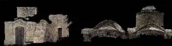
Figure 6. Snapshots of the initial point cloud parts from UMap software
The project required collaboration from multiple entities like the UN peacekeepers, police, military and regulating public bodies in the zone. The diverse landscape small timeframe with extreme weather conditions made the project quite tricky. Furthermore, the Church, surrounding landscape, and related artefacts have seen damages due to the access restriction and the environment.
Below is a brief outline of the paper
The Church is one of the oldest in the Famagusta region, built in the 12th century located in an unattached urban environment, prooving challenging to the survey planning and the digital documentation.
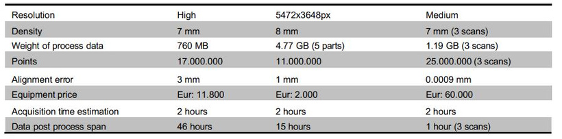
Geometry and colour information recording were chosen for 3D recording techniques implemented with their results compared and scientifically analysed.
New technologies allow easy access to 2D and 3D reconstruction tools and computer vision techniques such as photogrammetry and laser scanning.
In detail
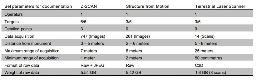
The project used two different photogrammetric techniques for the interior and exterior documentation, a laser scanner survey and a Gigapan Epic Pro Panoramic Head. Software required for post-processing were JRC Reconstructor, Surphaser (laser scanner software), MeshLab, Autodesk 123D, UMap – Menci and Adobe Photoshop Lightroom.
The paper entails
- Data Collection and methodology
- 3D modelling using photogrammetry: Image-based modelling for photogrammetric methods allows interpretation and measurements from 2D photographic images.
- Structure from motion (SFM): “3D model of the Church from 2D photographic images process is estimating 3D points from 2D images standard features in sequential images and calculating their trajectories over time.” The photography called for 261 pictures taken 30cm apart for the entirety of the Church using Canon EOS 6D with a Tamron 24-70 f2.8 lens on manual mode, as each image ought to overlap 60%. The images post-processing used the free software Autodesk, 123D Catch and the models using MeshLab, capturing the monument’s surface on a peripheral basis using UMap software, provided with the Z-Scan. The image sequences were processed to automatically reconstruct the corresponding point clouds, using ZMap software, a point cloud editing tool by Menci Software.
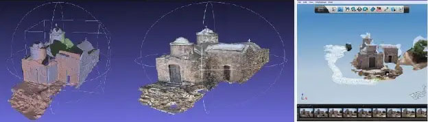
Figure 5. Aligned models from 123D Catch in MeshLab and the final 3D textured model. (SFM); Figure 4. Snapshot from 123D Catch. Result from 70 images. (SFM)
- Terrestrial laser scanning (TLS): Using a hemispherical Surphaser Terrestrial Laser Scanner and post processing and intergradation from Surphaser to JRC Reconstructor software
- Total Station and GPS – Georeference of the collected data: During the scanning and photo process, targets were placed at the Church’s two faces to reference results on a local system and their georeference, measuring them with a Leica Viva TS11 Total Station (TS).
- Documentation of the interior of the Church: Nikon D800 camera and a Gigapan Epic Pro Panoramic Head captured the panorama of the Church’s interior space and GigaPan Stitching software for the stitching.”The lens was an AF-S NIKKOR 14-24mm f/2.8G ED, set at 14mm focal length. The f-stop was f/10; the shutter speed was set at 1/8. Due to the poor natural lighting of the room, the ISO setting was put to 3600. The operation took about 15 minutes per panorama. To capture the whole of the Church, 6 panoramas were acquired, to be later linked via ‘hot’ points at the connecting part of the room (Figure 8)”
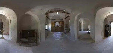
Figure 8. Panoramic image of the interior of the Church.
- Comparison and assessment of data
Our take
The paper is a beautiful example of cooperation and provides excellent insight into digital heritage documentation concisely and detailedly. We tried to include all the equipment and software used to offer an in-depth look at the process and get others inspired to learn and apply heritage digitisation.
I want to learn more:
Authors: Sorin Hermon, Franco Nicolucci, Kyriaki Yiakoupi, Alexia Kolosova, Giancarlo Iannone, Marina Faka, Panagiotis Kyriacou, Virginia Niccolucci
The Cyprus Institute, Science and Technology in Archaeology Research Centre (STARC), Nicosia, Cyprus
PIN, University of Florence, Italy
3D-ICONS: 3d Digitisation of Icons of European Architectural and Archaeological Heritage